How an entire community got disaster-ready
Emergency Preparedness Manager Raymond Riordan says people often ask him how his “Citizen Corps Council” was able to achieve participation from so many in the San Ramon community. He says a willingness to really listen to everyone’s point of view was key to the success of this program, which is described here in detail.
It started as an effort to tackle a common enemy: an earthquake fault in the San Ramon Valley. The fault is capable of a 6.8 Richter scale magnitude quake that splits the valley north to south. Compounded with other hazards (wildland vegetation that sweeps down from the open space into residential areas, creeks that meander through the valley with historical flooding impacts, and a major transportation route for hazardous materials that runs beside residential communities), a disaster could occur anytime.
The City of San Ramon, Town of Danville, San Ramon Valley Fire Protection District and San Ramon Valley Unified School District are separated by jurisdictional boundaries, elected councils and boards, budgets, daily priorities, and operational activities. But with a shared mission to prepare for emergencies, in June 2006, the four agencies signed a joint agreement to plan, train, and coordinate emergency preparedness activities and disaster response.
The cornerstone of the joint Citizen Corps Council agreement focused on creating and supporting a Community Emergency Response Team (CERT) program, managed by the fire district that would cover 155 square miles and 165,000 residents. Since June, 2006, elected officials from each of the four agencies met quarterly and assigned staff to coordinate efforts. Staff were tasked with looking at new ways to integrate trained volunteers into the local response plans and facilitate citizen preparedness and promote community readiness.
The results included over 650 trained CERT members, new CERT training modules (on communications, animal sheltering, and leadership), installation of amateur radio equipment at shelters, annual emergency fairs that reach over 4,000 residents, and a local readiness website, www.bereadysrv.org.
Most recently the focus turned to integrating CERT in collecting damage assessment information and reporting to the Emergency Operations Center during an emergency. The goal of the CERT damage assessment program has been to get as many eyes and ears out in the community to help identify where the critical emergencies are located, so that available emergency response resources can be focused on the highest priorities. Using trained CERT volunteers has provided responders with information that otherwise may not get to the EOC and gives us a boost in understanding what has happened.
Identifying Critical Infrastructure
One of the first major accomplishments of the San Ramon Valley Emergency Preparedness Citizen Corps Council (sorry there is no cool acronym) demonstrated the value of the collaboration. The Pre-Incident Aerial Surveys (PIAS) started as a program to document school facilities for “intruder on campus” incidents. It expanded to include sites that were considered critical to the community at large, which met the Department of Homeland Security’s definition of critical infrastructure, and included sites that would impact normal community activities, such as churches, parks and gathering locations, if the site were damaged or destroyed. In the 18 months of the project over 299 sites have been identified and documented in the valley.
The concept of documenting information on floorplans, facility layouts and noting them in plans has been around for quite some time. The PIAS addressed the problems of outdated layouts, faded blueprints and sometimes inaccessible data, and made it accessible to the firefighter on the rig and the officer on the beat.
The PIAS used high-resolution aerial photographs (not available on the internet), and overlaid detailed, consistent, and “ground-truthed” data. Input on each site plan came from multiple disciplines (private sector, schools, fire, law, public works, parks, planning, and community development). The information per site highlighted identifiable hazards and systems in place to protect the facility. With the aerial photo on the right side of the bound volume, a map of the surrounding area provided a valuable tool to identify potential impacts of one facility on another. The PIAS provided invaluable information that could be evaluated while responding to the scene. It has been tested in eight real responses, including the following:
- Following a bank robbery report, the officer on the beat contacted the sergeant in command, who had access to the PIAS map and quickly determined two possible directions of escape: down a creek bed, or in a back street area. Thanks to the aerial survey, cops caught their robber.
- When a patient at the local medical center was experiencing heart failure, the donor heart was airlifted from San Francisco Airport to downtown San Ramon. Because the PIAS identified helicopter landing sites in the area, authorities were able to alert the pilot as to where to safely land in the vicinity of the medical center. The patient received the heart transplant in good time.
- And when a cougar had been spotted on the grounds of the local middle school – likely eyeing its next meal – police determined the cougar’s most likely path and gave animal control authorities the survey information that led to the cougar’s capture.
Creating a Damage Assessment Tool
Now that we knew what our critical sites were, we realized that with so many sites, we did not have sufficient public agency resources to conduct a windshield survey for all sites at the same time. We needed to prioritize the sites and identify who would or could provide an initial assessment of each site following a catastrophic event. This required bringing together fire, police, public services and building inspection staff to determine an appropriate method to rate the sites and identify which sites to survey first, second or third priority.
The group reviewed six Vulnerability Rating (VR) systems, and determined that most were too complex to meet our needs. We didn’t need to know whether a building would survive a hazard, but what sites should be given a higher level of attention after an incident. Following two three-hour meetings, representatives of each jurisdiction:
- inventoried the general types of facilities within the jurisdictions,
- ranked them according to use, proximity to hazard zones and average daily population, and
- provided each with a designated color to indicate high (red), medium (yellow) and low (green) response priority. In general high priority sites included:
- Schools
- Day care centers
- Convalescent centers
- Hospitals • Government facilities
- Potential shelters In general medium priority sites included:
- Churches
- Business centers
- Hotels
- Large retail businesses
- Businesses with hazardous materials
The lowest priority sites included all remaining locations, such as parks without facilities and newly constructed buildings deemed non critical.
Creating a Guide
As a subset of the PIAS, we developed a damage assessment guide by reorganizing the sites by priority and removing all the detailed photos. The result included a high priority map, a medium priority map and a low priority map. Since the fire department would be a responder to the high priority sites, the high and medium sites were further organized around the ten fire stations across the district. With a map and a list of priority sites, the last two pieces to complete the guide were directions to each site that would direct responders in the most efficient means from each fire station, and a reporting form. In the end the guide included:
- List of high and medium priority sites,
- Map and turn by turn directions from a fire station to each nearby high priority site,
- Map and turn by turn directions from a fire station to each nearby medium priority site, and
- FEMA standardized reporting sheet.
Response Actions
Fire district personnel respond and conduct a “windshield survey” of each high priority site. Once fire personnel complete the initial round of all high priority sites in their “area”, the resources will return to a site that has major or catastrophic damage and provide needed aid. If the high priority sites are clear, then the fire personnel survey the medium priorities.
After checking their personal safety and the needs of the designated neighborhood, Community Emergency Response Teams will respond to medium and low priority sites utilizing the directions and listed sites. Both fire and Community Emergency Response Team personnel will document their visual assessment on the FEMA forms provided in the guide and report it into the central point of contact.
Information Tracking
Fire dispatch personnel will report the information into the City of San Ramon or Town of Danville Emergency Operations Center via phone or fire radio. Community Emergency Response Team personnel gather information at the designated CERT Incident Command Post and report into the amateur radio station located at the San Ramon Valley Fire Protection District Administration building which houses both the City of San Ramon and Town of Danville Emergency Operations Centers. An amateur radio operator at the San Ramon Valley Fire Protection District Administration building will conduct routine “nets” to collect the information from the field CERT teams and document information on an Excel spreadsheet. The information will be either transmitted electronically or printed and provided to the Damage Inspection unit in the Emergency Operations Center for data collection and action.
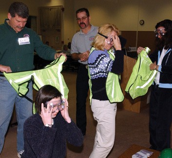
Training
CERT volunteers are trained to prepare and protect themselves, identify hazards, and report to the team, without putting themselves in harm’s way. The CERT teams already inspect their residential areas for damages, manage what they can, and report the information. As we tracked the high and medium priorities, they were located either within the residential area already patrolled by CERT or very nearby. Using CERT teams made sense as a support to the emergency response.
Communications training is the key to the success. To communicate with our Emergency Operations Centers, we train CERT on the use of FRS/GRMS radios to centralize information to a CERT Incident Command Post. From the ICP we use amateur radio to transmit data to the EOC. We optimize the opportunity of using the Amateur Radio Emergency Services (ARES) annual Simulated Exercise Test (SET) to prepare the CERT teams. Recently we used the September 26, 2009, SET to test the ability for amateur radio transmissions to capture the necessary information.
After a disaster strikes, timing is critical. Having these prepared strategies allows first responders, workplace employees, neighborhoods, faith-based organizations and schools to use their resources efficiently.
About the Author
Raymond Riordan is the Emergency Preparedness Manager for the City of San Ramon. Greg Gilbert is the Emergency Preparedness Manager for the Town of Danville. Danielle Bell is the Emergency Coordinator for the San Ramon Valley Fire Protection District who manages the CER T program.


Leave A Comment
You must be logged in to post a comment.